


Les Autels Villevillon 25.68

togolo28
User
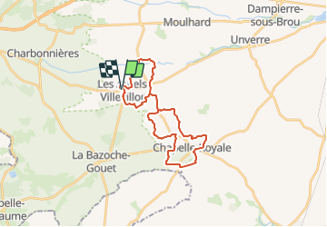

Length
26 km

Max alt
197 m

Uphill gradient
126 m
Km-Effort
27 km

Min alt
164 m

Downhill gradient
126 m
Boucle
Yes
Creation date :
2019-02-14 15:13:31.718
Updated on :
2019-02-15 11:51:48.784
--
Difficulty : Medium

FREE GPS app for hiking
 SityTrail
IGN / Geographical institutes
SityTrail Plus
The world is yours!
About
Trail On foot of 26 km to be discovered at Centre-Loire Valley, Eure-et-Loir, Les Autels-Villevillon. This trail is proposed by togolo28.
Description
Attention, 16,7 Km de route! Peu de chemins dans les environs!
Positioning
Country:
France
Region :
Centre-Loire Valley
Department/Province :
Eure-et-Loir
Municipality :
Les Autels-Villevillon
Location:
Unknown
Start:(Dec)
Start:(UTM)
351029 ; 5337570 (31U) N.
Comments